LUR:CNX

LURAF:OTCQB

Anna Lake

Labrador Uranium - Image - Bird Eye view

SNAPSHOT

Location:

Labrador, Canada (Central Mineral Belt)

Ownership:

100% interest

Deposit Type:

Uranium Vein-Type Deposit. Mineralization is hosted within strongly deformed metasedimentary rocks, with uranium mineralization associated with garnetiferous hornblende-biotite schist

Stage:

Prospect, Exploration

Primary Minerals:

Uranium

OVERVIEW

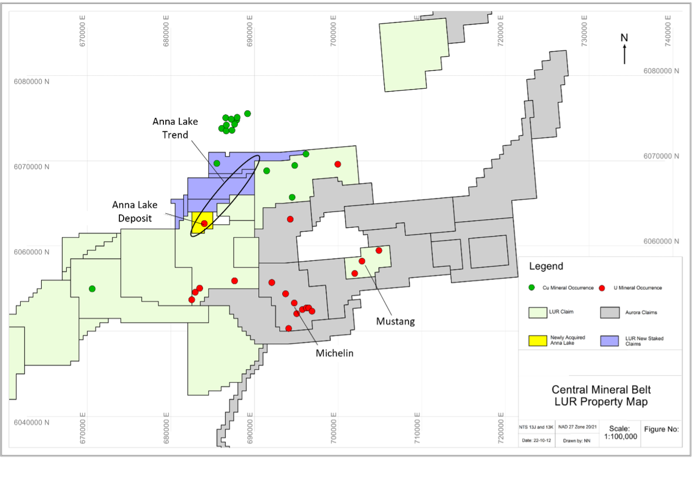
  • Located approx. 35 km southwest of Postville, and 15 km northwest of the Michelin deposit
  • Strike length of 750 m and extends down-dip to 663 m within a broadly undulating sheetlike body and is open in all directions.
  • Located 9 km to the west along strike from the Melody Hill prospect where significant high grade uranium values of up to 28.2% occur in granite boulders (now owned by Paladin Energy) and Melody Hill North prospect (owned by LUR).
  • Reconnaissance fieldwork conducted by LUR to the northeast during the 2022 field season revealed potential for a similar boulder train.

HISTORICAL MINERAL RESOURCES

Anna Lake Historic Mineral Resource Estimate (North And South)

Category

Cutoff

Mt

% U3O8

% Mo

Re (g/t)

Mlbs U3O8

Mlbs Mo

Mgms Re

Inferred

0.030%

5.1

0.044%

0.014%

0.198

4.91

1.56

1.00

GEOLOGY

  • The Anna Lake Project (Figure 2) is located approximately 35 kilometers southwest of the coastal community of Postville, Labrador, and 15 kilometers northwest of the Michelin Deposit held by Paladin Energy. The deposit occurs 9 km to the west along strike from the Melody Hill prospect where high grade uranium values of up to 28.2% U3O8 occur in granite boulders. 
  • Mineralization was first identified on the property in the 1970’s byBrinco who discovered an extensive radioactive boulder train which occurs along the southeast margin of a NE-SW trending linear, narrow magnetic high in association with a radiometric anomaly. Numerous large boulders and blocks (1 meters to 5 meters) of pegmatitic rock and metapelite occur in an area outlined by the magnetic high and rugged terrain, with topographic relief ranging from 10 m to 50 m. Radiometric response ranges from 200 cps to 6,000 cps on individual boulders, but also varies on the same boulders. 
  • Brinco collected 11 grab samples, taken from over 2,000 radioactive gossanous garnet-biotite schist boulders which assayed from 0.132% to 3.05% U3O8. Initial grab sampling was followed-up with limited drilling on potential source rocks which produced intercepts of 0.118% U3O8 over 1.5 metres and 0.10 % U3O8 over 2.0 metres in two separate, closely spaced drill holes (Bayswater Press Release – July 12, 2007).
  • Bayswater subsequently drilled a total of 22,355 meters of core drilling in 67 drill holes during their 2007 and 2008 field seasons. Based on these drilling campaigns, Bayswater produced an initial mineral resource estimate on the property.


Notes:

  1. The mineral resource estimate contained in this table is considered to be a “historical estimate” as defined under NI 43-101, and is not considered by LUR to be current and is not being treated as such. A Qualified Person has not done sufficient work to classify the historical estimate as current mineral resources. LUR would need to review and verify the scientific information and conduct an analysis and reconciliation of historical drill and geological data in order to verify the historical estimate as a current mineral resource.
  2. Reported by Bayswater Uranium Corporation in a Technical Report entitled “Form 43-101 Technical Report on the Anna Lake Uranium Project, Central Mineral Belt, Labrador, Canada”, prepared by R. Dean Fraser, P.Geo. and Gary H. Giroux, P.Eng., dated August September 30, 2009.
  3. A 3-dimensional geologic model of the deposit was created for the purpose of the resource estimate using the Gemcom/Surpac modeling software. A solid model was created using a minimum grade x thickness cutoff of 3 meters grading 0.03% U3O8. Intersections not meeting this cutoff were generally not incorporated into the model. The shell of this modeled zone was then used to constrain the mineralization for the purpose of the block model. Assay composites 2.5 meters in length that honoured the mineralized domains were used to interpolate grades into blocks using ordinary kriging. An average specific gravity of 2.93 was used to convert volumes to tonnes. The specific gravity data was acquired in-house and consisted of an average of seventeen samples collected from the mineralised section of the core. The resource was classified into Measured, Indicated or Inferred using semi-variogram ranges applied to search ellipses. All resources estimated at Anna Lake fall under the “Inferred” category due to the wide spaced drill density. Either LUR or Beaconsfield would need to conduct an exploration program, including twinning of historical drill holes in order to verify the Anna Lake Project estimate as a current mineral resource.


PLANNED WORK

  • Compile historic data and identify potential targets for expansion drilling
SIGNUP FOR LATEST NEWS